Bring life to your data with FME
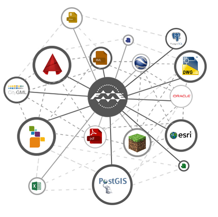
FME is a flexible and powerful spatial tool used by thousands of GIS experts all over the world for quick data translation, transformation, and integration. FME is used in electric power industries, local governments, communal services, and many other industries to simplify workflows for data integration using its powerful data conversion capabilities.
Regardless of whether the data is linked to spatial data, data storage or business intelligence, FME will help in their resolution. FME brings new possibilities of company integration, business performance optimization, and speeding up access to data with support for spatial data.
Increase data value and spend more time using obtained results.
FME Form
Fast CONVERSION of spatial data
FME Form is used for fast data conversion, transformation, and integration into hundreds of formats. Data can exist in multiple systems and databases.
FME Form is an efficient solution for data conversion which helps us get spatial data in the correct format and structure needed, using a quick and direct process.
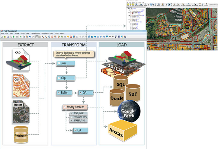
It is very simple to define the conversion flow through the graphic interface. Two flexible options are available: FME Quick Translator for simple and FME Workbench for complex conversions.


FME Form includes a gallery of over 500 powerful transformers which offer an unlimited number of ways to process spatial data.
Everyday data transformation tasks include:
- performing geometric operations
- combining data of different types from multiple different sources
- merging attributes from a database with a facility’s geometry
- preforming operations with attributes
- customizing a facility’s symbolization
Knowing and understanding data is key for the success of any transformation. For easy access to the structure and contents of data being processed, as well as monitoring the flow through the entire transformation process, FME Form includes FME Data Inspector.
By using the FME Workbench component, you can easily integrate several data types from several sources and create a unified data model for a project. FME Form can be used to combine vector and raster data, or you can link data from a CAD file with attributes from a database.
FME can be firmly integrated with many applications which enables the appropriate data conversion, transformation, and integration from a known environment. FME can be used together with these applications:
- autodesk AutoCAD Map 3D
- autodesk MapGuide
- ESRI ArcGIS
- inergraph GeoMedia
- PBBI MapInfo Professional
- Microsoft SQL Server Integration Services
- GE Smallworld

attribute data
operations
FME Flow
- is an adaptable platform which enables flexible distribution of data and services for their sharing
- uses the same FME mechanisms which make the core of FME Form
- transforms and shares spatial data using web services
- enables an efficient sharing of data on demand in one of several hundred formats
- delivers up to date spatial data in exactly in the form that is needed


Basic services
- Data Download
- Data Streaming
- Job Submitter
- KML Network Link
- Catalog Service
- OGC Web Feature Service
Additional sevices
- Data Upload
- Web Connection (SOAP)
- REST
Application
- offers a self-service approach to FME transformations
- instant presentation of data to the user in the form the user requested
- automatic operation
- one place for downloading a workbench, editing and reuploading
- the user doesn’t need to know how to use FME
Implementation of solutions
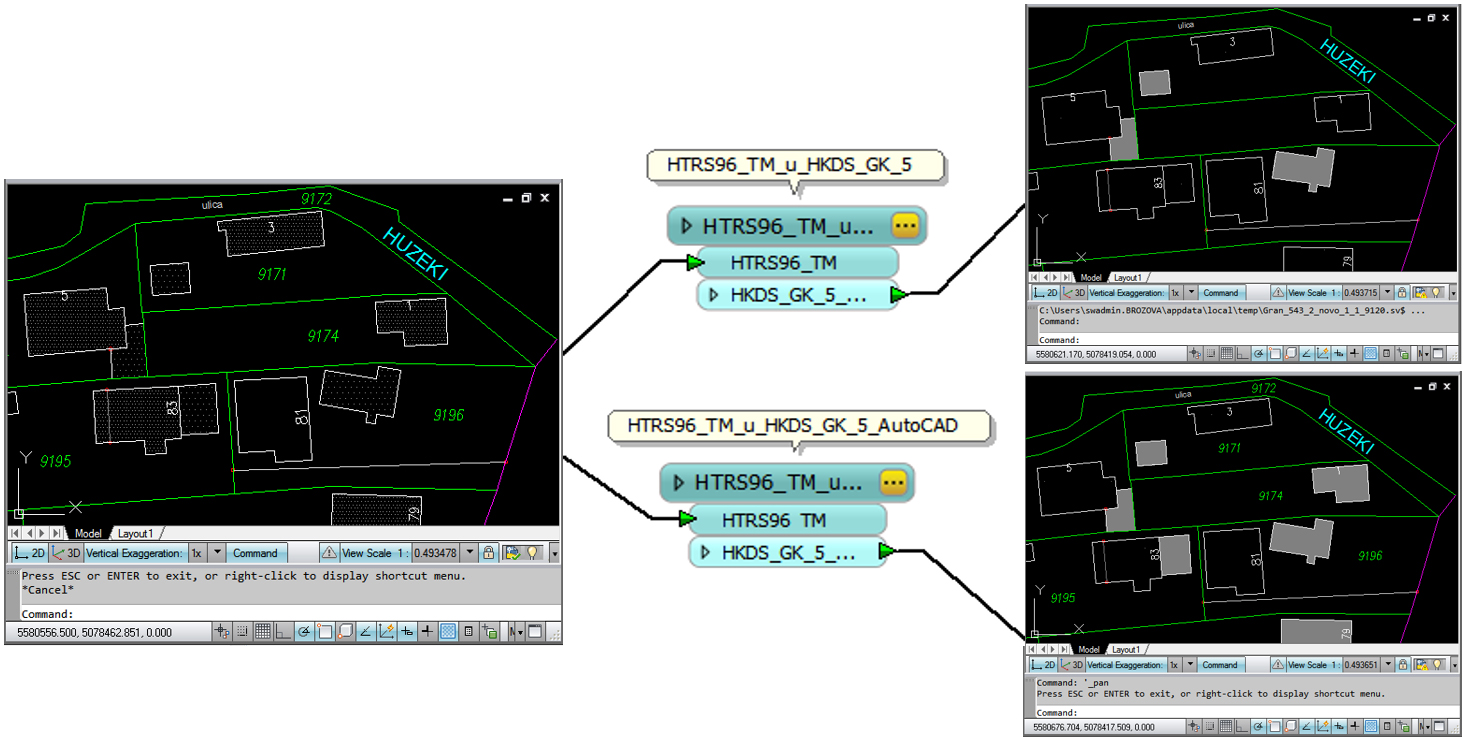
- coordinate system transformations (HDKS-HTRS96 module)
- control of data prepared for migration
- migrating data into a production database
- import/export from a production database into selected formats
- FME Flow usage statistics
- interface customization
FME Flow Hosted
FME Flow Hosted is a server (hosting) version of FME Flow. It is the ultimate platform for connecting through a web interface by combining the automation power of FME Flow with the flexibility of cloud technology. It is an exceptionally powerful tool that enables handling spatial data in applications such as Google Maps, ArcGIS Online, CARTO, OpenStreetMap, and more.
FME Flow Hosted has the unique ability to integrate workbenches designed as a response to an event or during a time interval in accordance with client requests.
- no work expenses or hardware
- high availability
- automated backup
- scalability
- optimized for data in a cloud
- controlled through FME Form
- flexible payment model
Don’t spend hours on installation and configuration. You can get this version of FME Flow completely functional and ready for operation in a few minutes. Even better, FME Flow Hosted can use “pay when you use” to respond to user needs. Pay for time spent only when you really need FME processing.

FME - Data Integration Platform
More than 500 functions which offer an unlimited number of various spatial data transformations.
More than 450 standard CAD, GIS, vector, raster and alphanumeric data formats, as well as all the relevant spatial databases.
Defining the process (programming) of transformation, control and other processes is done in a simple and intuitive graphic environment.

Top 10 ways to use FME
- data exchange between CAD and GIS
- loading and migration of spatial databases
- data model restructuring and transformation
- spatial and tabular data integration
- spatial data translation and conversion
- coordinate system conversion
- spatial data preview and control
- downloading geometry from traditional databases
- quality control and data verification
- data conversion between different formats
HDKS - HTRS96 Transformations
3D conversion between the old HKDS Gauss-Kruger 5th and 6th zone and the new HTRS96/TM projection

- complete CAD drawings in all supported vector formats (DWG/DXF, DGN...)
- geocoded orthophoto images
- geocoded scanned maps, plans and sketches in supported raster formats (TIF, JPG...)
- GIS database and other formats (Smallworld, ESRI, Oracle/Spatial...)
- point list in ascii, xls, db, or some other format
for migration


You don’t know which license to pick?
We offer free consultations with no obligation on your part. We can explore which license would be the right choice for your business. Request an offer or make an appointment today and find out how we can help you to increase the value of your data.


